Property Record
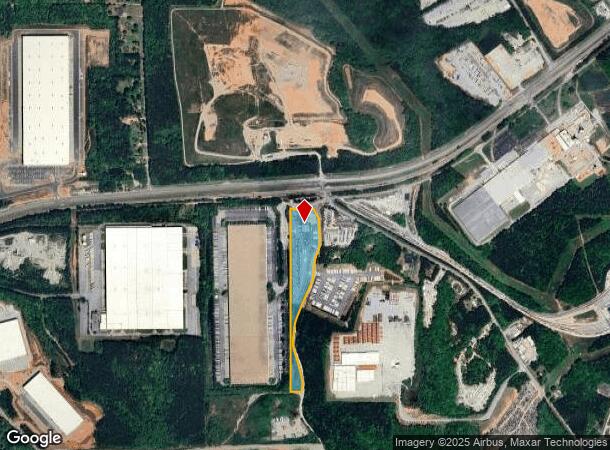
8105 Williams Rd, Palmetto, GA 30268

NEARBY LISTINGS FOR SALE OR LEASE
Property Detail
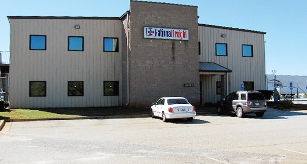
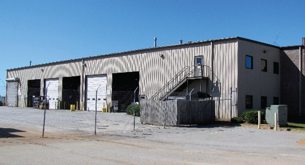
8105 Williams Rd
Truckterminal
Fulton
X
Georgia
13121C0445F
11.65 AC
2023
Airport/North Clayton
2023
Atlanta
010401
Atlanta-Sandy Springs-Roswell, GA
16,367 SF
07-2900-0133-170-3
DEMOGRAPHICS near 8105 Williams Rd
1 Mile
3 Mile
5 Mile
2024 Total Population
80
14,693
52,665
2029 Population
82
15,213
54,982
Pop Growth 2024-2029
+ 2.50%
+ 3.54%
+ 4.40%
Average Age
41
38
38
2024 Total Households
30
5,496
19,016
HH Growth 2024-2029
+ 3.33%
+ 3.44%
+ 4.36%
Median Household Inc
$57,142
$55,589
$67,074
Avg Household Size
2.60
2.70
2.70
2024 Avg HH Vehicles
2.00
2.00
2.00
Median Home Value
$194,444
$211,094
$245,896
Median Year Built
1992
1999
2001
Nearby Places
- Restaurants
- Banks
- Shops
- Fitness
- Groceries
PUBLIC TRANSPORTATION
AIRPORT
Hartsfield - Jackson Atlanta International
DRIVE
WALK
Distance
Hartsfield - Jackson Atlanta International
29 min
18.6 mi
Freight Ports
Georgia Ports - Savannah
DRIVE
WALK
Distance
Georgia Ports - Savannah
291 min
255.9 mi
Nearby Properties
Address
Land Use
TOTAL SIZE
Lot Size
Zoning
Address
Land Use
TOTAL SIZE
Lot Size
Zoning
938,714 SF
103.25 AC
AG1
Address
Land Use
TOTAL SIZE
Lot Size
Zoning
1,000,200 SF
78.26 AC
R1
Address
Land Use
TOTAL SIZE
Lot Size
Zoning
374,881 SF
91.05 AC
M1
Address
Land Use
TOTAL SIZE
Lot Size
Zoning
981,874 SF
83.45 AC
AG1
Address
Land Use
TOTAL SIZE
Lot Size
Zoning
1,160,240 SF
71.94 AC
AG1
Address
Land Use
TOTAL SIZE
Lot Size
Zoning
1,040,000 SF
74.64 AC
AG1
Address
Land Use
TOTAL SIZE
Lot Size
Zoning
373,175 SF
19.33 AC
M1
Address
Land Use
TOTAL SIZE
Lot Size
Zoning
415,580 SF
17.53 AC
C2
Address
Land Use
TOTAL SIZE
Lot Size
Zoning
873,600 SF
65.24 AC
C2
Address
Land Use
TOTAL SIZE
Lot Size
Zoning
1,351,440 SF
86.29 AC
M1
Address
Land Use
TOTAL SIZE
Lot Size
Zoning
1,054,500 SF
101.73 AC
M1
Address
Land Use
TOTAL SIZE
Lot Size
Zoning
262,734 SF
26.48 AC
C1
Address
Land Use
TOTAL SIZE
Lot Size
Zoning
355,271 SF
13.40 AC
PD
Address
Land Use
TOTAL SIZE
Lot Size
Zoning
254,363 SF
26.11 AC
C1
Address
Land Use
TOTAL SIZE
Lot Size
Zoning
491,992 SF
48.25 AC
M1
Address
Land Use
TOTAL SIZE
Lot Size
Zoning
556,800 SF
32.69 AC
M1
Address
Land Use
TOTAL SIZE
Lot Size
Zoning
510,180 SF
41.23 AC
M1
Address
Land Use
TOTAL SIZE
Lot Size
Zoning
715,114 SF
135.23 AC
M2
Address
Land Use
TOTAL SIZE
Lot Size
Zoning
350,000 SF
17.54 AC
M1
Address
Land Use
TOTAL SIZE
Lot Size
Zoning
139,164 SF
48.66 AC
R2
Address
Land Use
TOTAL SIZE
Lot Size
Zoning
417,540 SF
20.73 AC
M1
Address
Land Use
TOTAL SIZE
Lot Size
Zoning
242,550 SF
15.82 AC
AG1
Address
Land Use
TOTAL SIZE
Lot Size
Zoning
82,508 SF
7.30 AC
M2
Address
Land Use
TOTAL SIZE
Lot Size
Zoning
149,600 SF
17.58 AC
M1
Address
Land Use
TOTAL SIZE
Lot Size
Zoning
72,376 SF
30.30 AC
Address
Land Use
TOTAL SIZE
Lot Size
Zoning
54,542 SF
2.34 AC
C2
Address
Land Use
TOTAL SIZE
Lot Size
Zoning
90,360 SF
5.86 AC
C2
Address
Land Use
TOTAL SIZE
Lot Size
Zoning
41,956 SF
2.32 AC
M1
Address
Land Use
TOTAL SIZE
Lot Size
Zoning
40,682 SF
2 AC
M1
Address
Land Use
TOTAL SIZE
Lot Size
Zoning
The World's #1 Commercial Real Estate Marketplace
Connect with us
© 2025 CoStar Group
The information above has been obtained from sources believed reliable. While we do not doubt its accuracy we have not verified it and make no guarantee, warranty or representation about it. It is your responsibility to independently confirm its accuracy and completeness. Any projections, opinions, assumptions, or estimates used are for example only and do not represent the current or future performance of the property. The value of this transaction to you depends on tax and other factors which should be evaluated by your tax, financial, and legal advisors. You and your advisors should conduct a careful, independent investigation of the property to determine to your satisfaction the suitability of the property for your needs.